Rivers
Recent Articles
More Articles

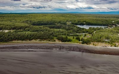
Valdez, Mineral Creek
Valdez is a community situated on the outwash fan of Mineral Creek on the north shore and near the head of Port Valdez in northeastern Prince William Sound, about 82 miles (132 km) east-northeast of Whittier and 46 miles (74 km) north-northwest of Cordova, Alaska.

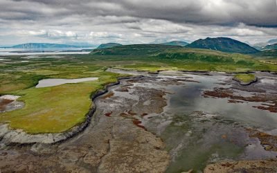
Kotzebue, Baldwin Peninsula
Kotzebue is a community situated between Cape Blossom to the south and Pipe Spit to the east near the tip of the Baldwin Peninsula that separates Kotzebue Sound from Hotham Inlet, about 149 miles (240 km) southeast of Point Hope and 73 miles (117 km) west-northwest of Selawik, Alaska.

Campbell Creek, Turnagain Arm
Campbell Creek starts at the confluence of the North and South forks in Campbell Park on the western flank of the Chugach Mountains and flows generally southwest for 10 miles (16 km) through the city of Anchorage to Campbell Lake, and the lake outflow then enters Turnagain Arm about 8 miles (13 km) northwest of Potter and 6.5 miles (10.5 km) south-southwest of downtown Anchorage, Alaska.

Deering, Kotzebue Sound
Deering is a community situated on a barrier spit at the mouth of the Inmachuk River on Kotzebue Sound on the northern coast of the Seward Peninsula between Cape Deceit to the west and Ninemile Point to the east, about 155 miles (250 km) east-northeast of Point Hope and 57 miles (92 km) south of Kotzebue, Alaska.
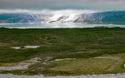
Fourpeaked Glacier, Shelikof Strait
Fourpeaked Glacier starts from the eastern flank of Fourpeaked Mountain with a summit elevation of 6771 feet (2,064 m) and flows generally east for 6 miles (10 km) to a proglacial lake about 2.5 miles (4 km) long that is drained by a river that flows another 0.8 miles (1.3 km) to Shelikof Strait in Katmai National Park and Preserve, about 90 miles (145 km) southwest of Homer and 77 miles (124 km) northwest of Kodiak, Alaska.

Kiwalik, Spafarief Bay
Kiwalik is a historical Iñupiat hunting and fishing camp, that became a major logistical base for mining activities in the Candle area, situated on a spit between Kawalik Lagoon to the south and Spafarief Bay to the north on the northeast coast of the Seward Peninsula, about 148 miles (238 km) northeast of Nome and 64 miles (103 km) south-southeast of Kotzebue, Alaska.
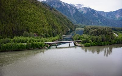
Kasiks River, Skeena River
Kasiks River is a tributary that enters the Skeena River about 55 miles (89 km) upstream from Chatham Sound, about 37 miles (60 km) east of Prince Rupert and 36 miles (58 km) southwest of Terrace, British Columbia.
Knik Village, Knik Arm
Knik village is a historic Dena’ina community situated between the northwest shore of Knik Arm in Cook Inlet to the east and Knik Lake to the west, about 18 miles (29 km) north-northeast of Anchorage and 13 miles (21 km) southwest of Wasilla, Alaska.
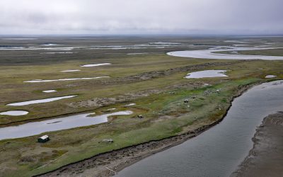
Cape Espenberg, Seward Peninsula
Espenberg is a historic Iñupiaq settlement and present-day fish camp at Cape Espenberg, a peninsula composed of a series of dune-covered beach ridges on the Chukchi Sea coast of the Seward Peninsula that extends eastward into Kotzebue Sound, about 63 miles (101 km) east-northeast of Shishmaref and 43 miles (69 km) southwest of Kotzebue, Alaska.
Chenik, Kamishak Bay
Chenik was a historical community at the mouth of Chenik Creek, between Chenik Lake to the west and Chenik Head to the east, on the west shore of Kamishak Bay, about 98 miles (158 km) northeast of King Salmon and 98 miles (158 km) southwest of Homer, Alaska.
About the background graphic
This ‘warming stripe’ graphic is a visual representation of the change in global temperature from 1850 (top) to 2019 (bottom). Each stripe represents the average global temperature for one year. The average temperature from 1971-2000 is set as the boundary between blue and red. The colour scale goes from -0.7°C to +0.7°C. The data are from the UK Met Office HadCRUT4.6 dataset.
Click here for more information about the #warmingstripes.