Shipwrecks
Recent Articles
More Articles
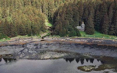
Monks Lagoon, Spruce Island
Monks Lagoon is on Icon Bay, a bight about 1 mile (1.6 km) across, on the southeastern shore of Spruce Island, about 6.6 miles (10.6 km) north of Kodiak and 5.7 miles (9 km) south-southeast of Ouzinkie, Alaska.
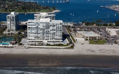
SS Monte Carlo, Coronado Shores
The shipwreck of the SS Monte Carlo is occasionally exposed by shifting sands during the winter on Coronado Shores, a wide sandy beach also known as South Beach, on Coronado Island about 4.5 miles (7.3 km) east of Point Loma and 3.4 miles (5.5 km) south of San Diego, California.
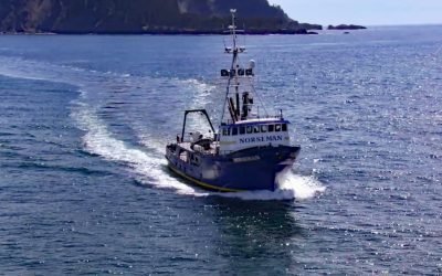
FV Norseman, Princess Royal Channel
The fishing vessel Norseman sank in June 1978 in Princess Royal Channel, about 11 miles (18 km) southeast of Butedale and 115 miles (185 km) southeast of Prince Rupert, British Columbia.

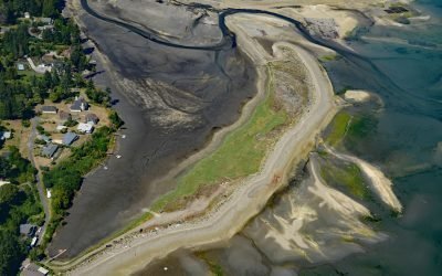
McLean Arm Bay, Prince of Wales Island
McLean Arm Bay is a narrow inlet that extends 6.5 miles (10.5 km) west from Clarence Strait, on the southeast coast of Prince of Wales Island, about 40 miles (65 km) southwest of Ketchikan and 40 miles (65 km) southeast of Hydaburg, Alaska.
Minter, Henderson Bay
Minter is a community on the northwestern shore of Henderson Bay, at the head of Carr Inlet in South Puget Sound, about 24 miles (39 km) southwest of Seattle and 5.5 miles (9 km) northwest of Gig Harbor, Washington.

Nikiski Bay, Cook Inlet
Nikiski Bay, formerly known as Nikishka Bay, is a bight in Upper Cook Inlet that extends southwest for 4 miles (6.5 km) from Boulder Point along the southeast shore of Gompertz Channel, 1 mile (1.6 km) north of the community of Nikiski and about 14 miles (22.6 km) north of Kenai, Alaska.

Star of Bengal, China Cove
China Cove is a small embayment, about 1.7 miles (2.7 km) wide, on the southeast coast of Coronation Island, located between Chatham and Sumner Straits, 93 miles (150 km) south-southeast of Sitka and 106 miles (171 km) northwest of Ketchikan, Alaska.

Uyak Bay, Kodiak Island
Uyak Bay extends south-southeast for 40 miles (65 km) off Shelikof Strait on the northwest coast of Kodiak Island, 59 miles (95 km) west-southwest of the community of Kodiak, Alaska.

Igalik Island, Dease Inlet
lgalik Island is an arctic barrier island and the easternmost of the Plover Islands, 2.5 miles (4 km) long, at the entrance to Dease Inlet, 36 miles (58 km) east-southeast of Utqiagvik, Alaska.

HMCS Mackenzie, Cornet Island
HMCS Mackenzie was a destroyer launched in 1961 and served until 1993 in the Royal Canadian Navy and in the Canadian Forces before being scuttled in Haro Strait in a channel between Cornet and Gooch Islands in the Southern Gulf Islands, about 18 miles (29 km) north-northeast of Victoria and 5 miles (8 km) east-northeast of Sidney, British Columbia.
About the background graphic
This ‘warming stripe’ graphic is a visual representation of the change in global temperature from 1850 (top) to 2019 (bottom). Each stripe represents the average global temperature for one year. The average temperature from 1971-2000 is set as the boundary between blue and red. The colour scale goes from -0.7°C to +0.7°C. The data are from the UK Met Office HadCRUT4.6 dataset.
Click here for more information about the #warmingstripes.