
by CoastView | Aug 15, 2025 | 2025, Biodiversity, British Columbia, Communities, Developments, Historical, Land Use, Natural History, Rivers
Listen to the article here https://coastview.org/wp-content/uploads/2025/06/Gingolx.mp3 Gingolx is located at the confluence of the Kincolith and Nass rivers on the northern shore of Nass Bay, approximately 70 miles (113 km) east-southeast of Ketchikan and 50 miles...

by CoastView | Aug 13, 2025 | 2025, Alaska, Coastal Features, Embayments, Historical, Islands, Land Use, Natural History, Rivers, Waterfalls
Listen to the article here https://coastview.org/wp-content/uploads/2025/06/Kasnyku-Falls.mp3 Kasnyku Falls is a waterfall on Kasnyku Creek, which flows about 1 mile (1.6 km) to Waterfall Cove on Baranof Island, approximately 23 miles (37 km) south-southwest of Angoon...

by CoastView | Aug 12, 2025 | 2025, Biodiversity, California, Coastal Features, Communities, Embayments, Historical, Land Use, Natural History, Rivers
Listen to the article here https://coastview.org/wp-content/uploads/2025/06/Albion-River.mp3 Albion River flows generally west-southwest for 18 miles (29 km) to the Mendocino Coast, about 22 miles (35 km) north of Point Arena and 6 miles (10 km) south-southeast of...
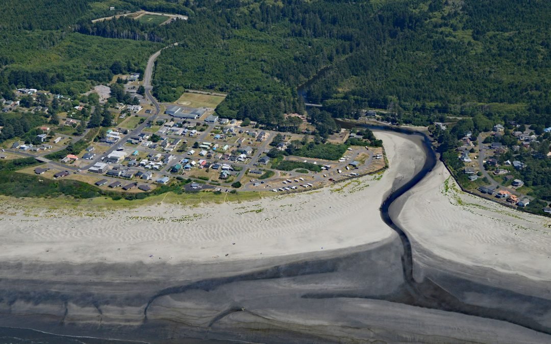
by CoastView | Aug 10, 2025 | 2025, Beaches, Coastal Features, Communities, Developments, Historical, Land Use, Natural History, Rivers, Washington
Listen to the article here https://coastview.org/wp-content/uploads/2025/07/Pacific-Beach.mp3 Pacific Beach is a community located at the mouth of Joe Creek, about 25 miles (40 km) northwest of Hoquiam and 11 miles (18 km) south of Moclips, Washington. Beach sands...

by CoastView | Aug 9, 2025 | 2025, Alaska, Biodiversity, Coastal Features, Embayments, Historical, Kachemak, Natural History, Parks, Rivers
Listen to the article here https://coastview.org/wp-content/uploads/2025/06/Moss-Harbor.mp3 Moss Harbor is a low-tide lagoon located at the head of China Poot Bay on the southern shore of Kachemak Bay, about 17 miles (27 km) northeast of Seldovia and 10 miles (16 km)...

by CoastView | Aug 8, 2025 | 2025, Beaches, British Columbia, Coastal Features, Communities, Historical, Islands, Land Use, Parks, Rivers, Shipwrecks
Listen to the article here https://coastview.org/wp-content/uploads/2025/06/Pezuta.mp3 The Tlell River flows generally north-northeast for 28 miles (45 km) to Hecate Strait, near the wreck of the steamship SS Pezuta, about 29 miles (47 km) south-southeast of Masset...