
by CoastView | Sep 18, 2025 | 2025, Alaska, Embayments, Islands
Listen to the article here https://coastview.org/wp-content/uploads/2025/06/Seal-Island.mp3 Seal Island, located in Prince William Sound, is an uninhabited and forested landmass approximately 0.5 miles (0.8 km) across, about 7 miles (11 km) east of Knight Island and...

by CoastView | Sep 17, 2025 | 2025, Alaska, Coastal Features, Headlands
Listen to the article here https://coastview.org/wp-content/uploads/2025/06/Point-Woronzof.mp3 Point Woronzof is a headland in Cook Inlet on the southern coast of Knik Arm, located 4 miles (6.5 km) west of downtown Anchorage, Alaska. The point was named after the...

by CoastView | Sep 16, 2025 | 2025, Alaska, Beaches, Biodiversity, Coastal Features, Developments, Historical, Land Use
Listen to the article here https://coastview.org/wp-content/uploads/2025/06/Point-Spencer.mp3 Point Spencer is located at the northern tip of a spit approximately 19 miles (31 km) long, situated between the Bering Sea and Port Clarence on the Seward Peninsula, about...

by CoastView | Sep 15, 2025 | 2025, Coastal Features, Communities, Historical, Land Use, Natural History, Oregon, Rivers
Listen to the article here https://coastview.org/wp-content/uploads/2025/06/Ophir.mp3 Ophir is a small community situated on Euchre Creek in Curry County, approximately 0.5 miles (0.8 km) upstream from the Pacific Ocean and about 4 miles (6.5 km) northeast of the...

by CoastView | Sep 14, 2025 | 2025, Alaska, Coastal Features, Communities, Developments, Historical, Kachemak, Land Use
Listen to the article here https://coastview.org/wp-content/uploads/2025/06/Millers-Landing.mp3 Millers Landing is located on the north shore of Kachemak Bay on the Kenai Peninsula, approximately 4 miles (6.5 km) northwest of Homer, Alaska. The local name was first...

by CoastView | Sep 13, 2025 | 2025, Beaches, British Columbia, Coastal Features, Communities, Embayments, Historical, Land Use, Natural History
Listen to the article here https://coastview.org/wp-content/uploads/2025/06/Willows-Beach.mp3 Willows Beach is a beachfront neighborhood located between Bowker Creek and Cattle Point at the head of Oak Bay in Victoria, British Columbia. The area derives its name from...

by CoastView | Sep 12, 2025 | 2025, Alaska, Communities, Embayments, Historical, Land Use
Listen to the article here https://coastview.org/wp-content/uploads/2025/06/Morzhovoi.mp3 Morzhovoi is an abandoned village on the southern shore of Trader Cove and the eastern shore of Bechevin Bay, on the Alaska Peninsula, about 5.5 miles (8.9 km) northeast of False...

by CoastView | Sep 11, 2025 | 2025, Alaska, Biodiversity, Canneries, Coastal Features, Communities, Embayments, Historical, Islands, Land Use, Natural History
Listen to the article here https://coastview.org/wp-content/uploads/2025/06/Mush-Bay.mp3 Mush Bay is a local name for a shallow embayment on the western shore of the East Arm of Uganik Bay on Kodiak Island’s west coast, about 22 miles (35 km) northeast of Larsen Bay...
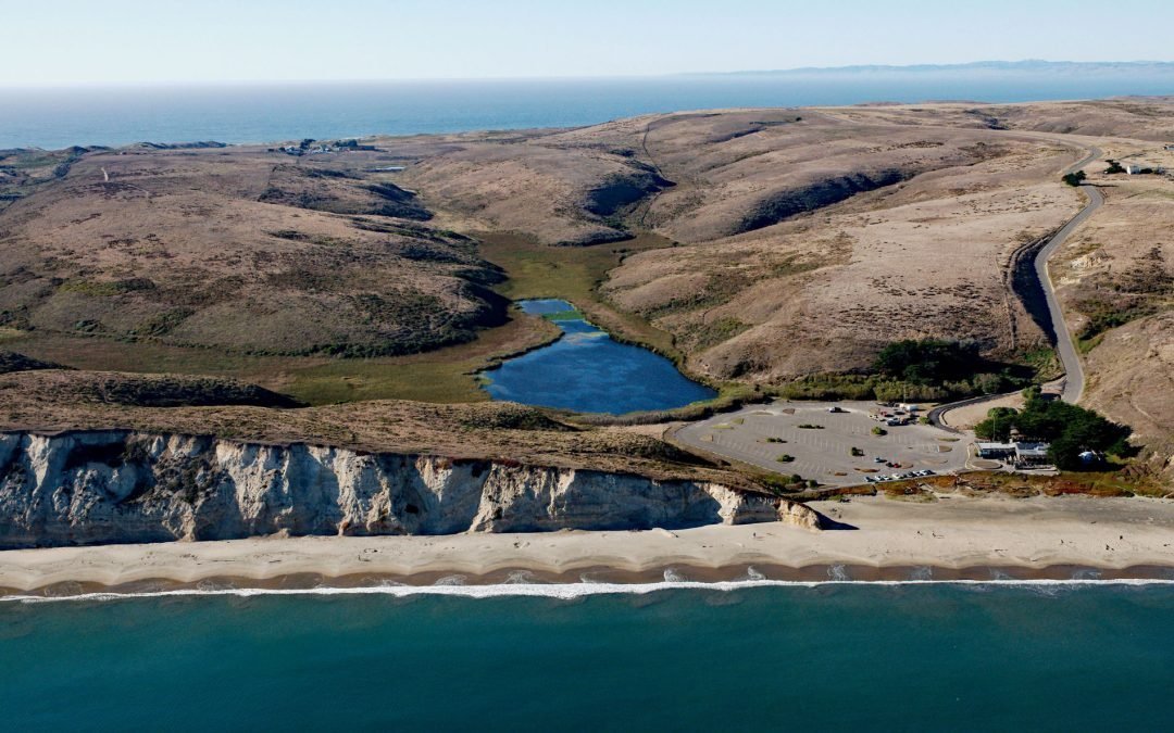
by CoastView | Sep 10, 2025 | 2025, Beaches, California, Coastal Features, Embayments, Land Use, Natural History, Parks
Listen to the article here https://coastview.org/wp-content/uploads/2025/06/Drake-Beach.mp3 Drakes Beach is a remote stretch of sand located in Point Reyes National Seashore at the head of Drakes Bay and adjacent to the Point Reyes State Marine Reserve, about 12 miles...
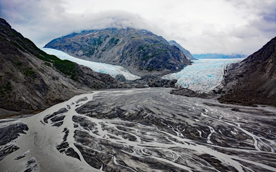
by CoastView | Sep 9, 2025 | 2025, Alaska, Coastal Features, Embayments, Glaciers, Historical, Land Use, Natural History, Parks
Listen to the article here https://coastview.org/wp-content/uploads/2025/06/Morse-and-Muir.mp3 Morse and Muir glaciers terminate at the head of Muir Inlet in Glacier Bay National Park and Preserve, approximately 53 miles (85 km) north of Gustavus, Alaska. Morse...