Lighthouses
Recent Articles
More Articles
Destruction Island, Quillayute Needles National Wildlife Refuge
Destruction Island is part of the Quillayute Needles National Wildlife Refuge, located 3.5 miles (6 km) offshore from the Olympic Peninsula, about 56 miles (90 km) southwest of Port Angeles and 17 miles (27 km) south-southeast of La Push, Washington.

Heceta Head Lighthouse, Heceta Head
Heceta Head Lighthouse is at an elevation of 205 feet (62 m) on the Heceta headland, about 13 miles (21 km) north of Florence, and 13 miles (21 km) south of Yachats, Oregon.

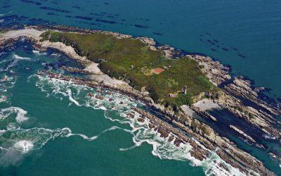
Cape Decision Lighthouse, Kuiu Island
Cape Decision is a headland on the southern end of Kuiu Island in Southeast Alaska, 105 miles (169 km) northwest of Ketchikan and 75 miles (121 km) southwest of Wrangell, Alaska.

Border Field State Park, Playas de Tijuana
Border Field State Park is within the Tijuana River National Estuarine Research Reserve situated adjacent to the urban neighborhood of Playas de Tijuana, Mexico, about 12 miles (19 km) south of San Diego and within the city limits of Imperial Beach, California.

Walton Lighthouse, Santa Cruz Harbor
Walton Lighthouse is situated on the west jetty at the entrance to the Santa Cruz harbor adjacent to Seabright State Beach, about 25 miles (40 km) north-northwest of Monterey and in the city of Santa Cruz, California.

Sitka Lighthouse, Galankin Islands
Sitka Lighthouse is privately owned and located at the northwestern end of Galankin Island in Sitka Sound between the Beardslee Islands to the west and Ball Islets to the east, about 43 miles (69 km) southwest of Angoon and 1 mile (1.6 km) south-southwest of Sitka, Alaska.

Santa Barbara Lighthouse, Santa Barbara
The Santa Barbara Lighthouse is located between the East Mesa and West Mesa neighborhoods, about 2 miles (3 km) west of Santa Barbara Harbor, in the City of Santa Barbara, California.

Brockton Point, Stanley Park
Brockton Point is a prominent peninsula in Stanley Park on the southern coast of Burrard Inlet that forms the north shore of Coal Harbour in the city of Vancouver, about 19 miles (30 km) north of Tsawwassen and 2.6 miles (4 km) southeast of West Vancouver, British Columbia.

Point No Point, Admiralty Inlet
Point No Point is a sand spit on the northern end of the Kitsap Peninsula, between Norwegian Point to the northwest and Pilot Point to the southeast, near the southern end of Admiralty Inlet that connects the Salish Sea with Puget Sound, about 8 miles (13 km) north of Kingston and 1.3 miles (2.1 km) southeast of Hansville, Washington.

Shelter Cove, Point Delgada
Shelter Cove is an isolated community on Point Delgada on the Lost Coast between Deadman Gulch to the south and Telegraph Creek to the north, about 54 miles (87 km) south of Eureka and 43 miles (69 km) north-northwest of Fort Bragg, California.
About the background graphic
This ‘warming stripe’ graphic is a visual representation of the change in global temperature from 1850 (top) to 2019 (bottom). Each stripe represents the average global temperature for one year. The average temperature from 1971-2000 is set as the boundary between blue and red. The colour scale goes from -0.7°C to +0.7°C. The data are from the UK Met Office HadCRUT4.6 dataset.
Click here for more information about the #warmingstripes.