Communities
Recent Articles
More Articles
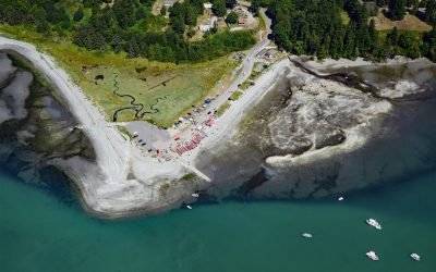
Little Boston, Point Julia
Little Boston is a community at the base of Point Julia on the east side entrance of Port Gamble, an inlet on the Kitsap Peninsula near the entrance to Hood Canal, about 21 miles (34 km) northwest of Seattle and 20 miles (32 km) southeast of Port Townsend, Washington.
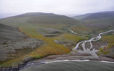
Kapaloak Creek, Cape Dyer
Kapaloak Creek starts from an elevation of roughly 1200 feet (366 m) in the Lisburne Hills and flows generally west for 8.5 miles (14 km) to Cape Dyer on the Chukchi Sea and the site of a historical Iñupiat village, about 110 miles (177 km) southwest of Point Lay and 25 miles (40 km) north-northeast of Point Hope, Alaska.

Blubber Bay, Texada Island
Blubber Bay is a community and an embayment on the northern tip of Texada Island, between the Strait of Georgia to the west and Malaspina Strait to the east, and the site of a historical shore whaling station and present-day limestone mine, about 76 miles (122 km) northwest of Vancouver and 5 miles (8 km) southwest of Powell River, British Columbia.
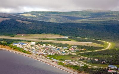
Elim, Norton Bay
Elim is a mixed Central Yup’ik and Iñupiaq community situated on the Iditarod Trail at the mouth of Elim Creek on the Seward Peninsula and the north shore of Norton Bay, about 39 miles (63 km) southwest of Koyuk and 24 miles (38 km) east-northeast of Golovin, Alaska.
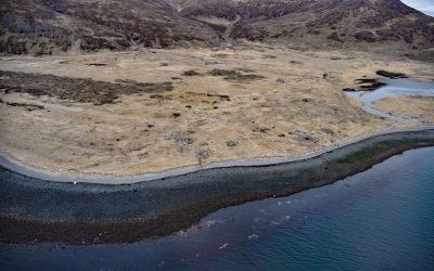
Ikatan Peninsula, Unimak Island
Ikatan Peninsula is connected to the northeastern tip of Unimak Island by a sand spit or tombolo separating Ikatan Bay to the north from Otter Cove to the south and is the site of the historical community of Ikatan, about 143 miles (230 km) northeast of Unalaska and 8 miles (13 km) south-southeast of False Pass, Alaska.

Whittier, Passage Canal
Whittier is a community and marine terminal for the Alaska Railroad and cruise ships, situated on the alluvial fan of Whittier Creek on the south shore of Passage Canal, a deglaciated fjord in northwestern Prince William Sound, about 82 miles (132 km) west-southwest of Valdez and 51 miles (82 km) southeast of Anchorage, Alaska.
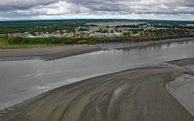
Kenai, Cook Inlet
Kenai is a community situated at the site of Shk’ituk’t, a historical Dena’ina village located on the west coast of the Kenai Peninsula, on the eastern shore of Cook Inlet at the mouth of the Kenai River, about 65 miles (15 km) southwest of Anchorage and 64 miles (103 km) north of Homer, Alaska.
Point Hope, Marryat Inlet
Point Hope is an Iñupiaq whaling community also known as Tikiġaq or Tigara, situated on a barrier spit that extends northwest from Cape Thompson and joins another spit that extends southwest from the Lisburne Peninsula to enclose several lagoons including Marryat Inlet and forms the Tigara Peninsula, about 228 miles (367 km) southwest of Wainwright and 73 miles (118 km) northwest of Kivalina, Alaska.

Valdez, Mineral Creek
Valdez is a community situated on the outwash fan of Mineral Creek on the north shore and near the head of Port Valdez in northeastern Prince William Sound, about 82 miles (132 km) east-northeast of Whittier and 46 miles (74 km) north-northwest of Cordova, Alaska.

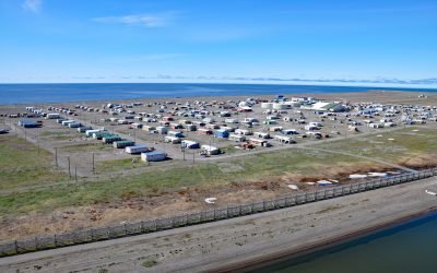
Kotzebue, Baldwin Peninsula
Kotzebue is a community situated between Cape Blossom to the south and Pipe Spit to the east near the tip of the Baldwin Peninsula that separates Kotzebue Sound from Hotham Inlet, about 149 miles (240 km) southeast of Point Hope and 73 miles (117 km) west-northwest of Selawik, Alaska.
About the background graphic
This ‘warming stripe’ graphic is a visual representation of the change in global temperature from 1850 (top) to 2019 (bottom). Each stripe represents the average global temperature for one year. The average temperature from 1971-2000 is set as the boundary between blue and red. The colour scale goes from -0.7°C to +0.7°C. The data are from the UK Met Office HadCRUT4.6 dataset.
Click here for more information about the #warmingstripes.