
by CoastView | May 10, 2025 | 2025, British Columbia, Chemical Pollution, Coastal Features, Communities, Developments, Embayments, Historical, Land Use
Listen to the article here https://coastview.org/wp-content/uploads/2025/08/Staovan-Marine-Terminal.mp3 The Stanovan Marine Terminal is located on the south shore of Burrard Inlet in Burnaby, at the western end of the Trans Mountain Pipeline, about 7 miles (11 km)...
by CoastView | May 9, 2025 | 2025, Alaska, Beaches, Biodiversity, Coastal Features, Historical, Kachemak, Land Use, Natural History, Parks, Rivers
Listen to the article here https://coastview.org/wp-content/uploads/2025/04/Humpy-Creek.mp3 Humpy Creek drains a watershed of 6,912 acres (2,797 ha) and flows northwest for about 4.5 miles (7 km) from Emerald Lake in the Kenai Mountains to the southeastern shore of...

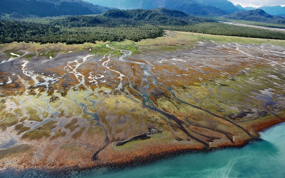
by CoastView | May 8, 2025 | 2025, Alaska, Biodiversity, Canneries, Climate Change, Coastal Features, Communities, Developments, Embayments, Historical, Land Use, Natural History, Parks
Listen to the article here https://coastview.org/wp-content/uploads/2025/04/Bartlett-Cove.mp3 Bartlett Cove is an estuary of the Bartlett River that extends northeast for 2 miles (3.2 km) from the eastern shore of Glacier Bay in Glacier Bay National Park and Preserve,...

by CoastView | May 7, 2025 | 2025, Beaches, Biodiversity, California, Coastal Features, Communities, Developments, Embayments, Historical, Land Use, Natural History, Parks
Listen to the article here https://coastview.org/wp-content/uploads/2025/04/Morro-Dunes.mp3 Morro Dunes form a barrier spit that separates Morro Bay to the east from the Pacific Ocean to the west, about 6 miles (10 km) south-southwest of the community of Morro Bay and...

by CoastView | May 6, 2025 | 2025, Alaska, Biodiversity, Canneries, Coastal Features, Embayments, Historical, Islands, Land Use, Natural History
Listen to the article here https://coastview.org/wp-content/uploads/2025/04/Parks-Cannery.mp3 Parks Cannery is located in Uyak Bay on the west coast of Kodiak Island, 24 miles (39 km) south of Shelikof Strait, 8 miles (13 km) south-southeast of Larsen Bay, and 61...

by CoastView | May 5, 2025 | 2025, Alaska, Beaches, Coastal Features, Communities, Developments, Embayments, Headlands, Historical, Islands, Land Use
Listen to the article here https://coastview.org/wp-content/uploads/2025/04/Dutch-Harbor.mp3 Dutch Harbor is an anchorage and fish-processing facility on the east coast of Amaknak Island, bordered by Mount Ballyhoo to the west and a gravel spit to the east that forms...

by CoastView | May 4, 2025 | 2025, Best of 2025, Coastal Features, Developments, Embayments, Historical, Land Use, Parks, Rivers, Washington
Listen to the article here https://coastview.org/wp-content/uploads/2025/04/Dismal-Nitch.mp3 Dismal Nitch is a cove on the north shore of the lower Columbia River, historically significant as the last campsite of the Lewis and Clark Expedition before they sighted the...

by CoastView | May 3, 2025 | 2025, British Columbia, Chemical Pollution, Coastal Features, Communities, Developments, Embayments, Historical, Land Use, Mines
Listen to the article here https://coastview.org/wp-content/uploads/2025/04/Kitsault.mp3 Kitsault is a historic mining community near the mouth of the Kitsault River, at the head of Alice Arm—a fjord and eastern extension of Observatory Inlet—about 86 miles (138 km)...

by CoastView | May 2, 2025 | 2025, Alaska, Biodiversity, Coastal Features, Embayments, Historical, Kachemak, Natural History, Rivers
Listen to the article here https://coastview.org/wp-content/uploads/2025/04/Seldovia-River.mp3 Seldovia River drains a watershed of 16,980 acres (6,872 ha) and flows generally northwest for 5 miles (8 km) from Seldovia Lake in the Kenai Mountains to Seldovia Bay, on...

by CoastView | May 1, 2025 | 2025, Alaska, Coastal Features, Embayments, Headlands, Historical, Land Use, Natural History
Listen to the article here https://coastview.org/wp-content/uploads/2025/04/Castle-Cape-1.mp3 Castle Cape extends about 10 miles (16 km) northeast from the Alaska Peninsula and forms the southern entrance to Chignik Bay, separating Castle Bay to the northwest from the...