
by CoastView | Jan 8, 2024 | 2024, Alaska, Beaches, Biodiversity, Coastal Features, Communities, Embayments, Land Use, Mines, Natural History, Rivers
Deering is a community situated on a barrier spit at the mouth of the Inmachuk River on Kotzebue Sound on the northern coast of the Seward Peninsula between Cape Deceit to the west and Ninemile Point to the east, about 155 miles (250 km) east-northeast of Point Hope...

by CoastView | Jan 7, 2024 | 2024, Alaska, Climate Change, Coastal Features, Glaciers, Natural History, Parks, Rivers
Fourpeaked Glacier starts from the eastern flank of Fourpeaked Mountain with a summit elevation of 6771 feet (2,064 m) and flows generally east for 6 miles (10 km) to a proglacial lake about 2.5 miles (4 km) long that is drained by a river that flows another 0.8 miles...

by CoastView | Jan 6, 2024 | 2024, Beaches, Biodiversity, California, Coastal Features, Developments, Embayments, Land Use, Natural History
Lawson’s Landing is a recreational area and campground on 75 acres (30 ha) in the Tomales Dunes Complex on Tomales Bay at Sand Point, about 20 miles (32 km) southwest of Santa Rosa and 1 mile (1.6 km) south of Dillion Beach, California. The landing is named after the...

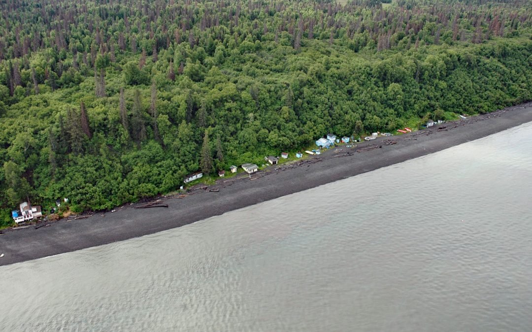
by CoastView | Jan 5, 2024 | 2024, Alaska, Chemical Pollution, Coastal Features, Communities, Embayments, Land Use, Natural History
Edna Bay is a community situated on 17,280 acres (6993 ha) in the Tongass National Forest on the southeast coast of Kosciusko Island off the northwest coast of Prince of Wales Island, about 61 miles (98 km) southwest of Wrangell and 18 miles (29 km) west-northwest of...
by CoastView | Jan 4, 2024 | 2024, Alaska, Coastal Features, Headlands, Historical, Land Use, Natural History, Shipwrecks
Ipiutak is the Iñupiaq name for a prehistorical village that is now an archaeological site and National Historic Landmark on the Tigara Peninsula and the southern shore of Ipiutak Lagoon, about 133 miles (215 km) southwest of Point Lay and 1 mile (1.6 km) northwest of...

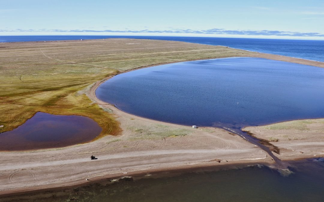
by CoastView | Jan 3, 2024 | 2024, Alaska, Beaches, Biodiversity, Coastal Features, Communities, Embayments, Land Use, Mines, Rivers
Kiwalik is a historical Iñupiat hunting and fishing camp, that became a major logistical base for mining activities in the Candle area, situated on a spit between Kawalik Lagoon to the south and Spafarief Bay to the north on the northeast coast of the Seward...
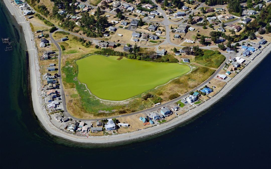
by CoastView | Jan 2, 2024 | 2024, Beaches, Coastal Features, Communities, Developments, Embayments, Headlands, Historical, Land Use, Washington
Diamond Point is a community on the northeast tip of the Miller Peninsula which forms part of the Olympic Peninsula on the Strait of Juan de Fuca at the entrance to Discovery Bay, about 44 miles (71 km) northwest of Seattle and 7.5 miles (12 km) west-southwest of Port...
by CoastView | Jan 1, 2024 | 2024, Alaska, Beaches, Coastal Features, Communities, Embayments, Headlands, Land Use, Natural History
Point Possession is a headland on the northern shore of the Kenai Peninsula near the confluence of Cook Inlet and Turnagain Arm, about 44 miles (71 km) northeast of Kenai and 20 miles (32 km) southwest of Anchorage, Alaska. The point was named in 1778 by Captain James...

by CoastView | Dec 31, 2023 | 2023, Biodiversity, British Columbia, Coastal Features, Natural History, Rivers
Kasiks River is a tributary that enters the Skeena River about 55 miles (89 km) upstream from Chatham Sound, about 37 miles (60 km) east of Prince Rupert and 36 miles (58 km) southwest of Terrace, British Columbia. Skeena River flows for 350 miles (570 km), draining a...

by CoastView | Dec 30, 2023 | 2023, Alaska, Biodiversity, Coastal Features, Communities, Developments, Embayments, Historical, Land Use, Natural History
Elephant Point is a headland and the site of a fish camp near a historical reindeer station in Eschscholtz Bay at the head of Kotzebue Sound, about 56 miles (90 km) southeast of Kotzebue and 20 miles (32 km) north-northwest of Buckland, Alaska. The bay was discovered...