
by CoastView | Aug 13, 2024 | 2024, British Columbia, Communities, Developments, Historical, Islands, Land Use, Rivers
Prince Rupert is a port community on Kaien Island, just north of the mouth of the Skeena River, and linked by a short bridge to the British Columbia mainland, about 465 miles (748 km) northwest of Vancouver and 90 miles (145 km) southeast of Ketchikan, Alaska. The...

by CoastView | Aug 12, 2024 | 2024, Alaska, Beaches, Communities, Islands, Rivers
Tyonek is a historical Dena’ina Athabascan community situated on a bluff on the northwest shore of Cook Inlet, about 43 miles (69 km) west-southwest of Anchorage and 35 miles (56 km) north of Kenai, Alaska. The village name is derived from the word Tyone meaning...

by CoastView | Aug 11, 2024 | 2024, Alaska, Communities, Developments, Embayments, Historical, Land Use, Mines, Parks, Rivers
Skagway is a community at the mouth of the Skagway River, near the head of Taiya Inlet, about 90 miles (145 km) northwest of Juneau and 16 miles (26 km) north-northeast of Haines, Alaska. The town is named after the Skagway River that leads to White Pass. The name...

by CoastView | Aug 10, 2024 | 2024, California, Climate Change, Coastal Features, Headlands, Historical, Lighthouses, Sea Caves
Point Arena is a narrow headland about 0.5 miles (0.8 km) long with a historical lighthouse that marks a significant change in the orientation of the Mendocino Coast, about 34 miles (55 km) south of Fort Bragg and 4 miles (6.4 km) northwest of the community of Point...

by CoastView | Aug 9, 2024 | 2024, Alaska, Best of 2025, Coastal Features, Developments, Historical, Islands, Lighthouses
Cape Sarichef is located at the southwestern end of Unimak Island, at the northwestern entrance to Unimak Pass on the Bering Sea coast, and on the northwest flank of Pogromni Volcano, about 80 miles (129 km) northeast of Dutch Harbor and 63 miles (101 km)...

by CoastView | Aug 8, 2024 | 2024, Beaches, Biodiversity, Climate Change, Coastal Features, Embayments, Historical, Oregon, Shipwrecks
Boiler Bay Intertidal Research Reserve is a rocky embayment 0.6 miles (1 km) wide between Government Point to the south and Rabbit Rock to the north, and an intertidal research reserve, about 9 miles (14.5 km) south of Lincoln City and 1.6 miles (2.6 km) north of...

by CoastView | Aug 7, 2024 | 2024, Biodiversity, British Columbia, Coastal Features, Embayments, Historical, Islands
Whaler Bay is located on the southeast end of Galiano Island adjacent to Sturdies Bay and across the island from Montague Harbour, about 28 miles (45 km) south-southwest of Vancouver and 18 miles (29 km) north of Sidney, British Columbia. Galiano Island is one of the...

by CoastView | Aug 6, 2024 | 2024, Alaska, Beaches, Biodiversity, Climate Change, Coastal Features, Embayments, Islands
Stockdale Harbor is on the northwest coast of Montague Island in Prince William Sound, about 62 miles (100 km) southeast of Whittier and 54 miles (87 km) southwest of Cordova, Alaska. In 1776, Nathaniel Portlock joined HMS Discovery as master’s mate under the...

by CoastView | Aug 5, 2024 | 2024, Alaska, Beaches, Canneries, Climate Change, Coastal Features, Communities, Freshwater, Glaciers, Historical, Rivers
Situk River starts at Situk Lake and flows southwest for about 18 miles (29 km) through the Yakutat Forelands in Tongass National Forest to Johnson Slough on the Gulf of Alaska, about 200 miles (322 km) northwest of Juneau and 9 miles (15 km) southeast of Yakutat,...
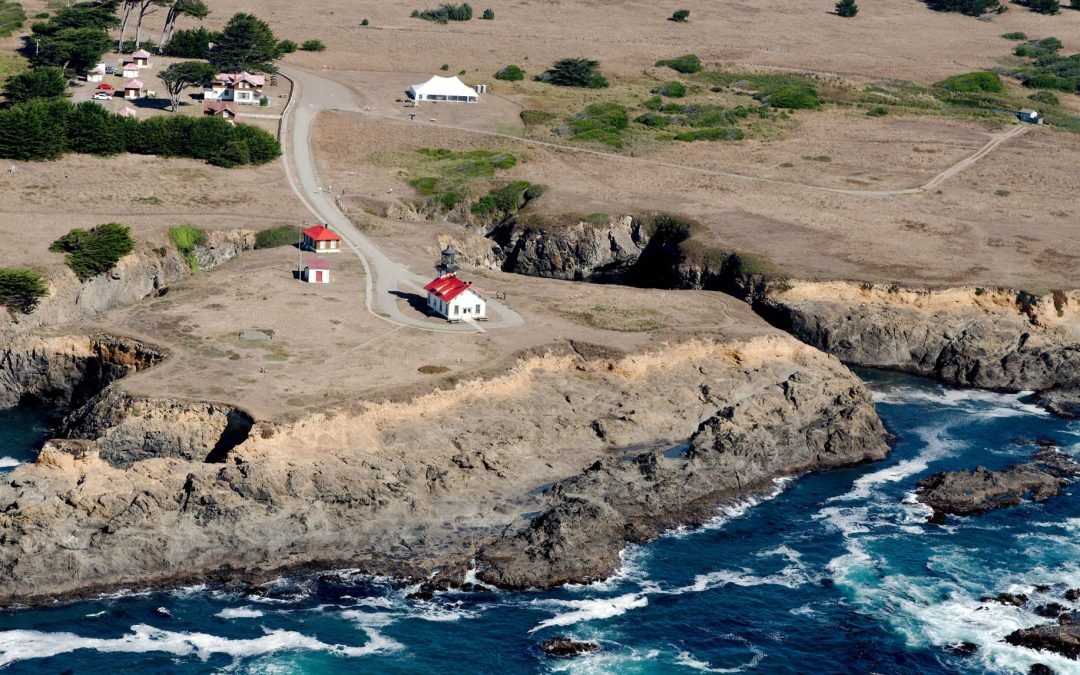
by CoastView | Aug 4, 2024 | 2024, California, Coastal Features, Developments, Headlands, Historical, Land Use, Lighthouses, Parks, Shipwrecks
Point Cabrillo is a sandstone headland marked with a lighthouse, between Point Arena and Cape Mendocino, about 6.7 miles (11 km) south of Fort Bragg and 1.3 miles (2 km) southwest of Caspar, California. The point was named in 1870 by the U.S. Geological Survey for the...