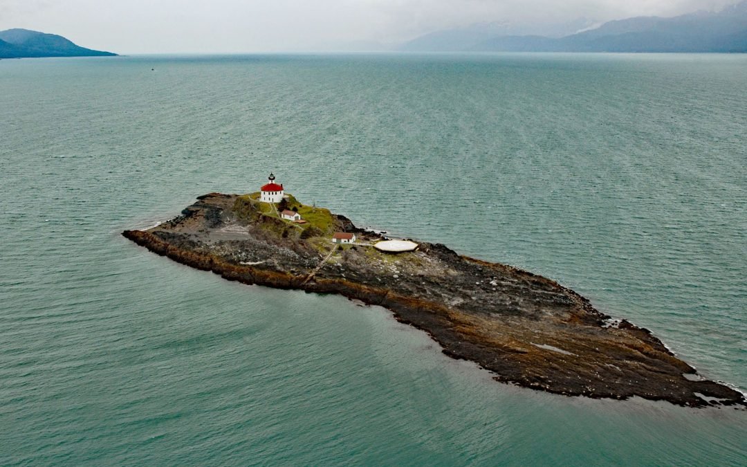
by CoastView | Apr 15, 2024 | 2024, Alaska, Coastal Features, Developments, Embayments, Islands, Land Use, Lighthouses, Natural History, Shipwrecks
Eldred Rock is a small island and site of a historic lighthouse situated adjacent to Sullivan Island in Lynn Canal, between the Chilkat Range to the west and the Kakuhan Range to the east, about 55 miles (89 km) northwest of Juneau and 20 miles (32 km) south-southeast...
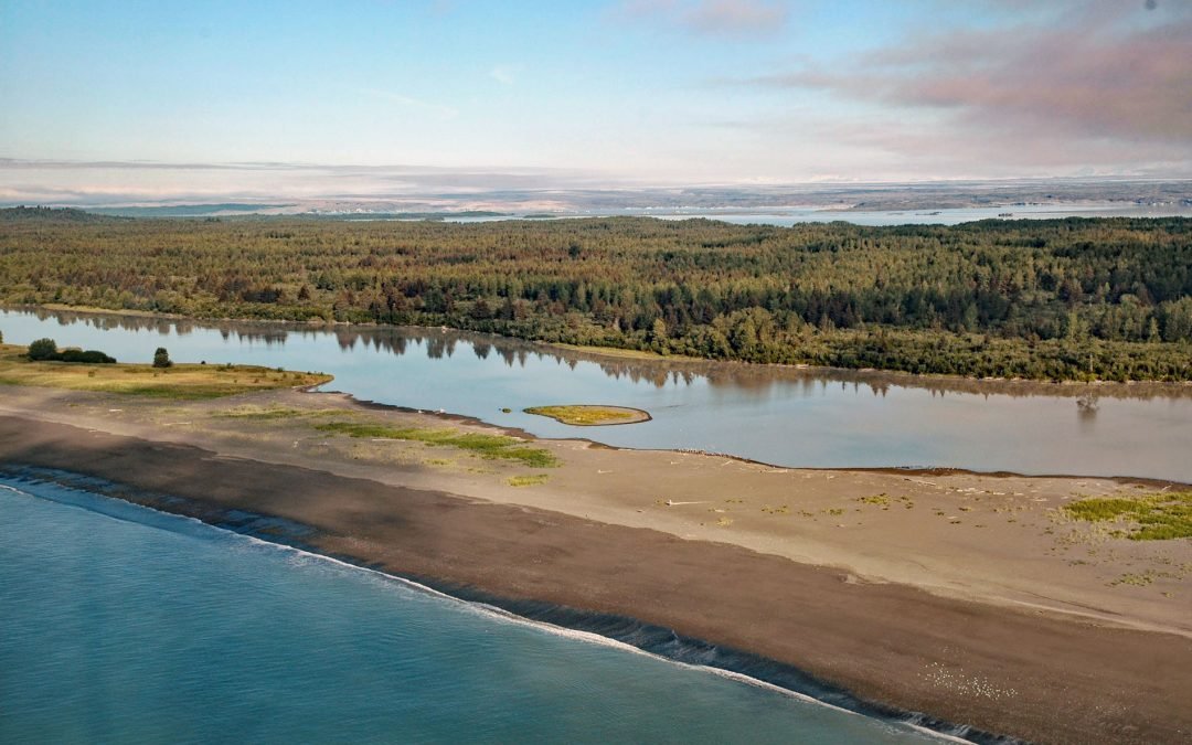
by CoastView | Apr 14, 2024 | 2024, Alaska, Beaches, Biodiversity, Coastal Features, Glaciers, Land Use, Natural History, Parks, Rivers
Sudden Stream drains the Malaspina Coastal Plain, flowing generally south for 2 miles (3.2 km) from the outlet of Malaspina Lake, a proglacial lake at the terminus of the Malaspina Glacier, to a lagoon formed by a barrier spit called Schooner Beach on Yakutat Bay,...
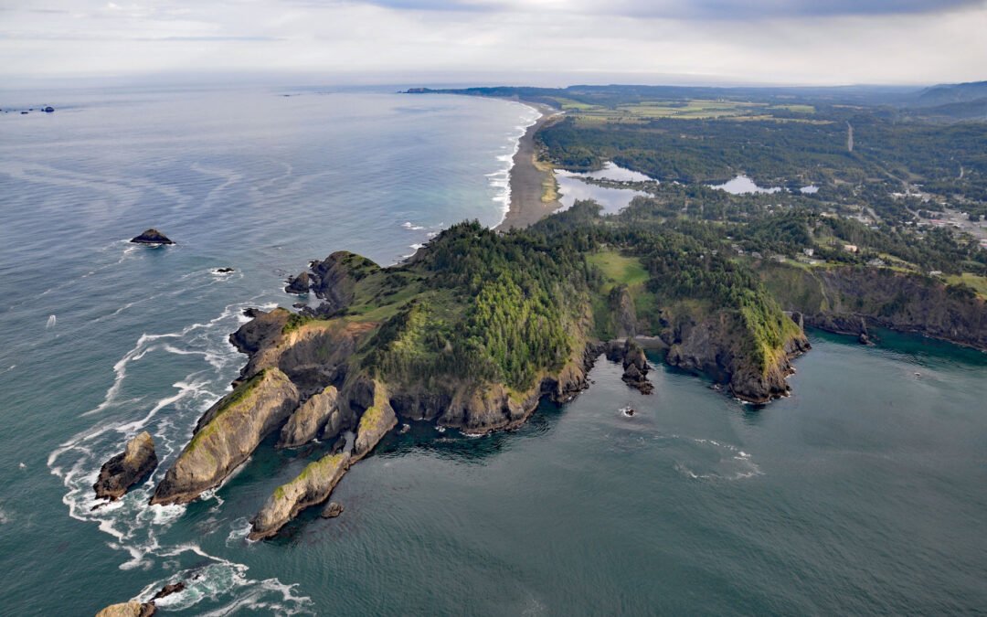
by CoastView | Apr 13, 2024 | 2024, Biodiversity, Coastal Features, Developments, Headlands, Land Use, Natural History, Oregon, Parks
Nellies Cove is situated on the south side of a rocky headland known as The Heads, between Agate Beach to the north and Port Orford to the south, and is the site of a historic lifeboat station in Port Orford Heads State Park, about 23 miles (37 km) north of Gold Beach...
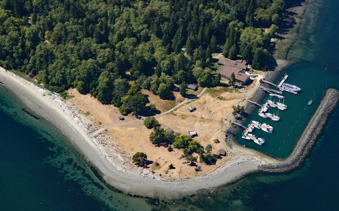
by CoastView | Apr 12, 2024 | 2024, Beaches, Coastal Features, Developments, Embayments, Islands, Land Use, Natural History, Parks, Washington
Blake Island is a Washington State Marine Park in Puget Sound situated between Bainbridge Island to the north and Vashon Island to the south, about 8 miles (13 km) southwest of downtown Seattle and 7 miles (11 km) east of Port Orchard, Washington. The island was named...
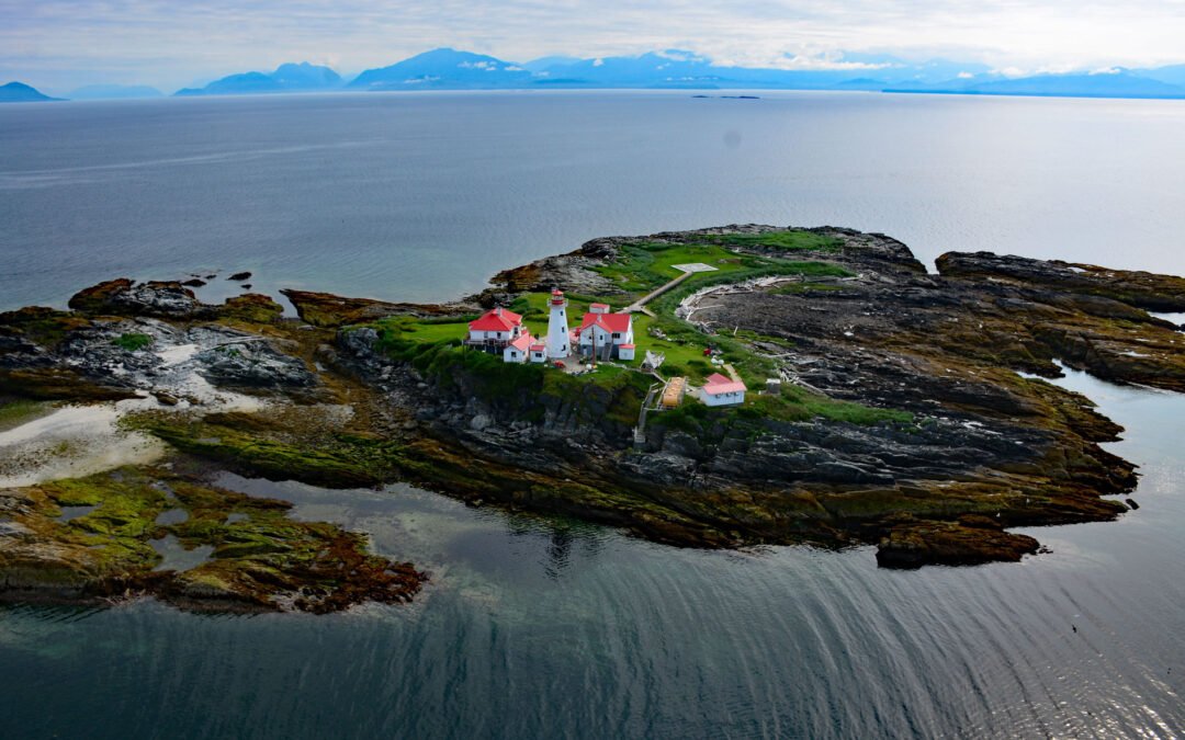
by CoastView | Apr 11, 2024 | 2024, British Columbia, Coastal Features, Islands, Land Use, Lighthouses, Natural History, Parks, Shipwrecks
Green Island is part of the Dundas Island Archipelago situated on the west side of Chatham Sound and is the site of a historic lighthouse, about 65 miles (105 km) south-southeast of Ketchikan and 24 miles (39 km) northwest of Prince Rupert, British Columbia. The...
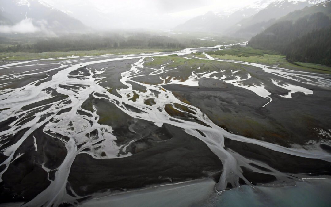
by CoastView | Apr 10, 2024 | 2024, Alaska, Beaches, Coastal Features, Developments, Embayments, Glaciers, Land Use, Mines, Natural History, Parks
Nuka River starts from Bradley Pass in the Kenai Mountains at an elevation of roughly 1400 feet (427 m) and flows generally south for 10 miles (16 km), draining a watershed of 34,503 acres (13,963 ha), to Beauty Bay between Storm Mountain to the north and Mount Diablo...
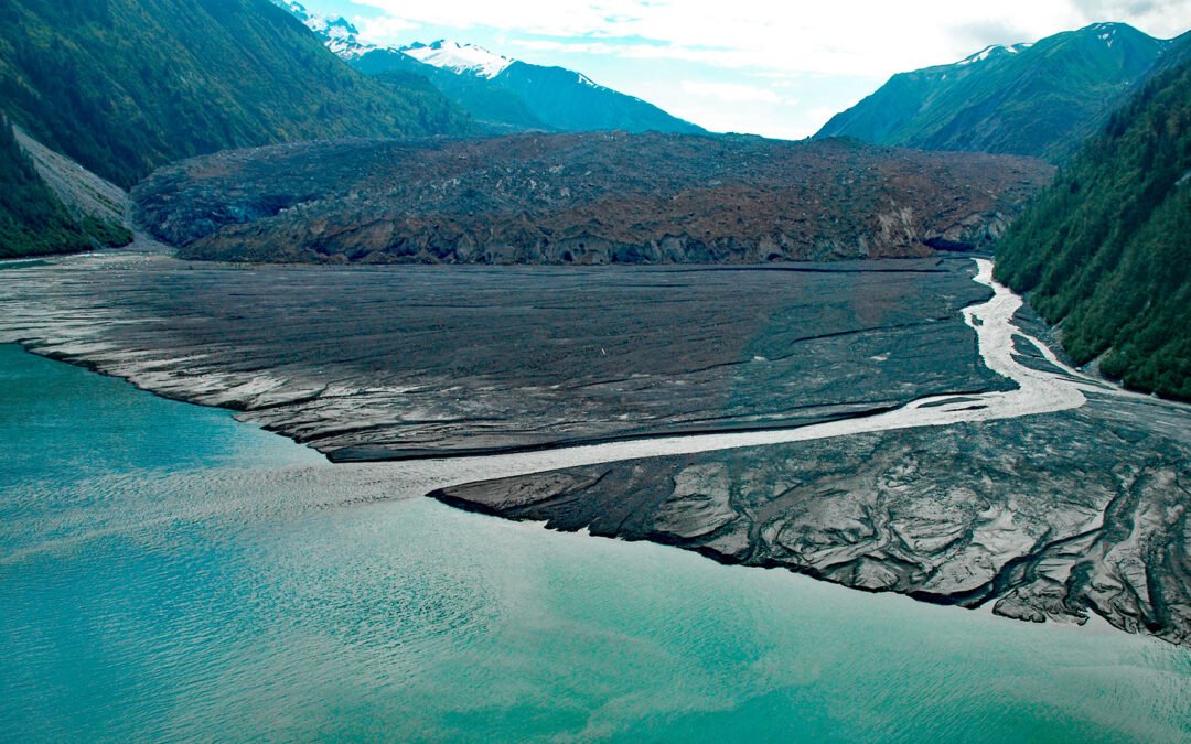
by CoastView | Apr 9, 2024 | 2024, Alaska, Climate Change, Coastal Features, Embayments, Glaciers, Natural History, Parks
North Crillon Glacier starts from a cirque at an elevation near 6,200 feet (1,890 m) on the west flank of Mount Crillon in the Fairweather Range, and flows generally southwest for 9 miles (15 km) and then makes an abrupt turn to the north and continues for another 3...
by CoastView | Apr 8, 2024 | 2024, Alaska, Beaches, Chemical Pollution, Coastal Features, Headlands, Natural History
Gore Point is a major headland with a summit elevation of 1411 feet (430 m) on the outer coast of the Kenai Peninsula that extends 2.5 miles (4 km) into the Gulf of Alaska, about 83 miles (134 km) south-southwest of Seward and 37 miles (60 km) south-southeast of...
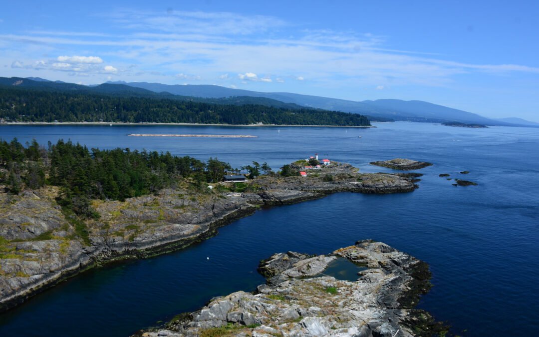
by CoastView | Apr 7, 2024 | 2024, British Columbia, Coastal Features, Embayments, Islands, Lighthouses, Natural History
Merry Island is situated at the southern entrance to Welcome Passage in Malaspina Strait, between the Thormanby Islands to the west and the Sunshine Coast, about 39 miles (63 km) west-northwest of Vancouver and 3 miles (5 km) south of Halfmoon Bay, British Columbia....
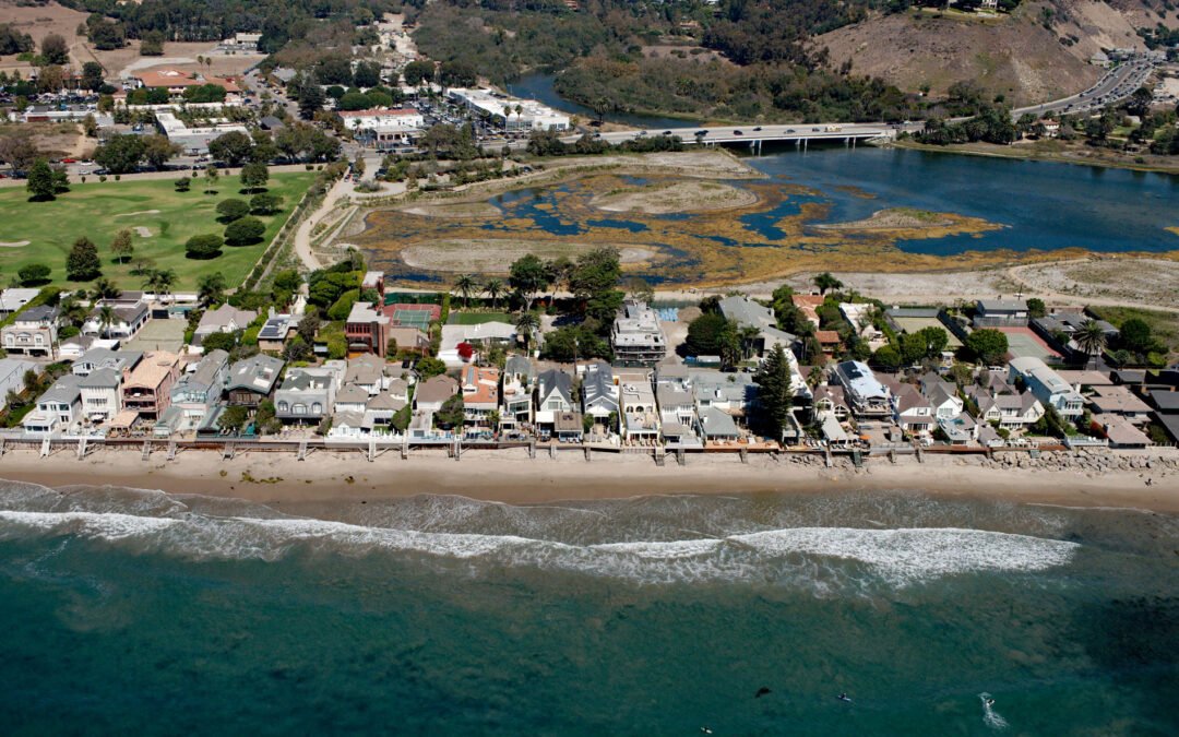
by CoastView | Apr 6, 2024 | 2024, Beaches, Biodiversity, California, Coastal Features, Communities, Developments, Embayments, Land Use, Natural History, Rivers
Malibu Lagoon is an estuary formed by a spit on the north shore of Santa Monica Bay that partially encloses the mouth of Malibu Creek, about 26 miles (42 km) west of downtown Los Angeles and in the community of Malibu, California. The name ‘malibu’ is...